
06 Nov, 2025
4 min read
Super Typhoon Nando Exits PAR but Continues to Intensify Southwest Monsoon; New Cyclone Opong Expected to Enter
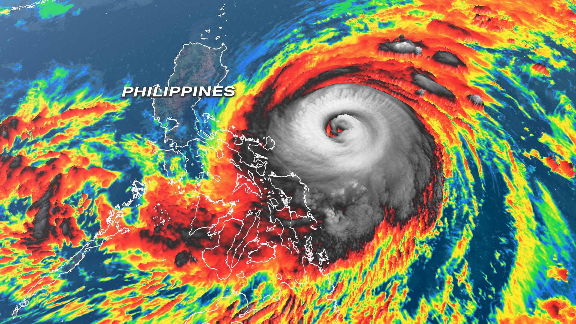
MANILA, Philippines – Although Super Typhoon Nando (Ragasa) departed from the Philippine Area of Responsibility (PAR) early Tuesday, September 23, it continues to exert significant influence on weather conditions across Northern Luzon by intensifying the southwest monsoon, locally known as habagat. Simultaneously, the country is preparing for the arrival of a newly formed tropical cyclone, expected to enter PAR later the same day.
At 10 a.m. on Tuesday, Nando was located approximately 385 kilometers west-northwest of Calayan, Cagayan, moving toward China at a speed of 20 kilometers per hour. It is projected to make landfall on Chinese soil on the evening of September 24 or the early hours of September 25. Upon exiting the Philippine jurisdiction at 4:50 a.m., Nando’s maximum sustained winds had reduced to 185 km/h, with gusts reaching 230 km/h.
Nando reached peak intensity with sustained winds of 215 km/h when it made landfall on Panuitan Island, Cagayan, on Monday, September 22. Despite its departure, PAGASA reports that Nando continues to enhance the southwest monsoon, resulting in heavy rains across several provinces.
From noon September 23 to noon September 24, La Union, Pangasinan, Benguet, Zambales, and Bataan are expected to experience heavy to intense rainfall between 100 and 200 millimeters. Meanwhile, moderate to heavy showers (50-100 mm) are forecast for Ilocos Norte, Ilocos Sur, Tarlac, Pampanga, Cavite, Batangas, and Occidental Mindoro.
From noon September 24 to noon September 25, moderate to heavy rains will likely persist in Zambales, Bataan, and Occidental Mindoro. Metro Manila and neighboring regions will see scattered rain showers and thunderstorms.
Although the typhoon is no longer within PAR boundaries, tropical cyclone wind signals remain active in parts of Northern Luzon. Signal No. 2, indicating gale-force winds of 62 to 88 km/h, remains in effect for western Babuyan Islands, northwestern Cagayan, northern Apayao, and Ilocos Norte. Signal No. 1, representing strong winds of 39 to 61 km/h, continues across Batanes, other Babuyan Islands, much of Cagayan, northern Isabela, Abra, Kalinga, Mountain Province, and additional areas.
The southwest monsoon combined with Nando’s trough also generates strong to gale-force gusts in Zambales, Bataan, Aurora, Nueva Ecija, Bulacan, Metro Manila, Calabarzon, Mimaropa, Camarines Norte, and Western Visayas on September 23, extending to more regions through the following days.
Furthermore, PAGASA warns of minimal to moderate risks of storm surges reaching 1 to 2 meters in specific coastal and island areas including northwestern mainland Cagayan, Babuyan Islands, Ilocos Norte, and northern Ilocos Sur.
Sea conditions remain hazardous with very rough to high waves up to 5.5 meters in the seaboards of Batanes, Ilocos Norte, and Babuyan Islands. Rough to moderate seas persist in several eastern and western coastal areas, advising small vessels to exercise caution.
Nando was the 14th tropical cyclone of 2025 to affect the Philippines and the fourth this September. Attention now turns toward a new system, tentatively named Opong, which elevated from a low-pressure area to a tropical depression outside PAR early Tuesday morning.
As of 10 a.m., Opong was situated 1,075 kilometers east of Eastern Visayas, moving west swiftly at 35 km/h with sustained winds of 55 km/h and gusts up to 70 km/h. PAGASA forecasts Opong’s entry into PAR by Tuesday afternoon or evening, moving generally west-northwest toward Eastern Visayas and Southern Luzon.
The tropical cyclone is expected to cross Southern Luzon, including regions such as Bicol, Calabarzon, and Mimaropa between September 26 and 27, before exiting PAR by Saturday evening. While the track is still subject to change, PAGASA warns Opong may strengthen into a tropical storm by Wednesday, with the possibility of further intensification to severe tropical storm status.
Preparations are underway, with Signal No. 1 potentially raised in Eastern Visayas as early as Wednesday, providing up to 36 hours of warning for strong winds. Furthermore, Signal No. 2 could be imposed over parts of Southern Luzon and Eastern Visayas, and Signal No. 3 may be declared if the system reaches severe tropical storm intensity.
Rainfall precipitated by Opong is anticipated to begin on Thursday, with heavy to intense rainfall forecast for Northern Samar and Eastern Samar, and moderate to heavy rains expected in multiple nearby provinces through Friday.
PAGASA also noted that from Thursday afternoon onward, moderate to rough seas may affect Eastern Visayas and northeastern Mindanao, warranting continued vigilance especially for coastal and maritime activities.
Residents and local authorities are urged to remain alert and adhere to official updates as weather conditions evolve over the coming days.
Recommended For You

Shane Gentallan Captures IBF Asia Jr. Flyweight Title in Bohol Boxing Showdown
Nov 06, 2025
Urbano Tolentino

Peaceful Trillion Peso March Held Across Negros Island Despite Heavy Rain
Nov 06, 2025
Eusebio Alcaraz
Nepal Forms Panel to Probe Deadly Anti-Corruption Protest Violence
Nov 06, 2025
Caridad Pingol

Independent Commission Denounces Document Tampering in Flood Control Investigations
Nov 06, 2025
Urbano Tolentino