
19 Sep, 2025
3 min read
Tropical Depression Mirasol Makes Landfall in Aurora, Prompting Weather Warnings Across Northern Luzon
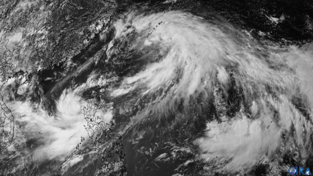
Tropical Depression Mirasol made landfall over Casiguran, Aurora early Wednesday morning, September 17, according to the Philippine Atmospheric, Geophysical, and Astronomical Services Administration (PAGASA).
"At 3:20 a.m. today, the center of Tropical Depression MIRASOL made landfall over Casiguran, Aurora," PAGASA stated in its tropical cyclone update.
The agency's 4:00 a.m. forecast placed Mirasol over the coastal waters of Casiguran, with maximum sustained winds of 55 km/h near the center and gusts reaching up to 90 km/h. The system is moving northwestward at 10 km/h.
Strong winds from Mirasol extend up to 200 kilometers from its center, prompting PAGASA to issue Tropical Cyclone Wind Signal (TCWS) No. 1 across multiple provinces in Luzon. Affected areas include Batanes, Cagayan including Babuyan Islands, Isabela, Quirino, parts of Nueva Vizcaya and Aurora, Apayao, Abra, Kalinga, Mountain Province, Ifugao, Ilocos Norte, northern Ilocos Sur, Polillo Islands, and northern Camarines Norte.
PAGASA noted that the expected wind speeds may cause minimal to minor damage to life and property, although some localized areas could experience stronger gusts.
Weather and Rainfall Outlook
The southwest monsoon, or "habagat," continues to influence weather conditions in Southern Luzon as well as western parts of Visayas and Mindanao.
Regions such as Cagayan Valley, the Cordillera Administrative Region, Aurora, Ilocos Norte, Ilocos Sur, and the Polillo Islands are expected to experience rains accompanied by gusty winds due to Tropical Depression Mirasol. PAGASA warned of potential flooding and landslides from moderate to heavy rainfall, while also cautioning against the effects of strong winds.
Metro Manila, other parts of the Ilocos Region, Central Luzon, and Calabarzon will likely see cloudy skies with scattered rain showers and thunderstorms caused by Mirasol. The agency highlighted risks of flash floods and landslides in these areas.
Meanwhile, the Bicol Region, MIMAROPA, Western Visayas, Negros Island Region, Central Visayas, and the Zamboanga Peninsula remain under the influence of the habagat, with expected rains and thunderstorms that could trigger flash floods or landslides.
Other parts of the Philippines will experience partly cloudy to cloudy conditions with isolated rain showers or thunderstorms. PAGASA noted the possibility of flash floods or landslides during strong localized thunderstorms.
Maritime conditions are expected to be rough, with waves between 1.5 to 3.2 meters occurring in northern and eastern Luzon, as well as parts of the Visayas. Mariners, especially operators of motorbancas, are urged to exercise caution or avoid venturing out to sea.
Forecast and Potential Intensification
PAGASA projects Mirasol to cross Northern Luzon and re-enter the Luzon Strait by Wednesday evening, where it is anticipated to strengthen into a tropical storm, potentially evolving into a severe tropical storm.
If intensification occurs, Tropical Cyclone Wind Signal No. 2 may be raised in some Northern Luzon locations.
Additionally, PAGASA reported the presence of another low-pressure area outside the Philippine Area of Responsibility with a medium chance of developing into a tropical depression within the next 24 hours.
Officials and residents in flood- and landslide-prone zones are advised to remain alert, observe local disaster preparedness protocols, consider evacuation if necessary, and stay updated through official weather advisories.
Recommended For You
Court of Appeals Freezes Bank Accounts, Insurance Policies Linked to Flood-Control Fund Diversion
Sep 19, 2025
Tino Salonga

UN Human Rights Chief Condemns Israeli Strike on Hamas Negotiators in Doha
Sep 19, 2025
Tino Salonga

Charlie Kirk Amplifies Conservative Youth Movements in Asia Ahead of Fatal Utah Shooting
Sep 19, 2025
Tino Salonga
A Mother’s Race Against Time, Won by 911
Sep 19, 2025
Ciriaco Manlapig