
19 Sep, 2025
3 min read
Tropical Storm Nando Intensifies, Poses Potential Threat to Northern Luzon
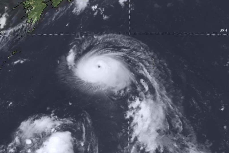
The Philippine Atmospheric, Geophysical and Astronomical Services Administration (PAGASA) reported early Friday, September 19, that Tropical Storm Nando (international name: Ragasa) has slightly intensified while progressing west-northwest over the Philippine Sea.
As of 4 a.m., the storm's center was located approximately 1,075 kilometers east of Central Luzon. TS Nando currently sustains maximum winds of 75 km/h near its core, with gusts reaching up to 90 km/h and a central pressure of 998 hPa. It is moving at a speed of 15 km/h toward the west-northwest, producing gale-force winds extending up to 380 kilometers from its center.
At present, no Tropical Cyclone Wind Signals (TCWS) are in effect. However, PAGASA indicated that Signal No. 1 could be raised over Northern Luzon as early as Saturday, September 20. Authorities further warned that if Nando intensifies into a super typhoon, the highest alert level, Signal No. 5, might be imposed.
"Nando will continue to strengthen while traversing the Philippine Sea and is likely to reach typhoon status by Saturday evening," PAGASA stated. The weather bureau also emphasized that a transition to super typhoon intensity is possible as the storm approaches Extreme Northern Luzon.
Although direct effects on the country’s weather are not expected within the next 48 hours, Nando's interaction with the southwest monsoon (locally known as habagat) may enhance rainfall, leading to heavy showers from Sunday, September 21, or Monday, September 22.
Residents in Ilocos Region, Zambales, Bataan, Bicol Region, and Eastern Visayas may experience strong to gale-force gusts on Friday. These conditions could extend to Bicol, Eastern Visayas, and Caraga on Saturday, followed by Bicol Region, Visayas, Northern Mindanao, and Caraga on Sunday.
Sea conditions are currently stable but will deteriorate starting Sunday, with moderate to rough seas expected along most coastal areas of Luzon. Wave heights could reach up to 14 meters near Extreme Northern Luzon. PAGASA cautioned that storm surge warnings might be necessary for coastal communities in Northern Luzon starting Saturday.
Forecasts project that Nando will follow a west-northwest course, possibly making a brief loop around September 19 before advancing toward Extreme Northern Luzon. The storm may pass near or make landfall over the Babuyan Islands between Monday evening, September 22, and Tuesday morning, September 23, before exiting the Philippine Area of Responsibility by late Tuesday.
PAGASA continues to advise residents, particularly those in areas susceptible to flooding and landslides, to remain vigilant and prepare for potential evacuations. Disaster risk reduction agencies are urged to implement precautionary measures in anticipation of the storm's intensification.
"Preparedness is essential as Nando may bring intensified conditions across northern regions," the agency concluded.
Recommended For You

Vivant Energy Expands Renewable Portfolio with 40% Stake in Bataan Solar Project
Sep 19, 2025
Urbano Tolentino

Senator Jinggoy Estrada Expresses Willingness to Open Bank Accounts Amid Corruption Allegations
Sep 19, 2025
Tino Salonga

Davao City Partners with Major Fast Food Chains to Employ Senior Citizens and PWDs
Sep 19, 2025
Urbano Tolentino

Cebu City Council Calls for Comprehensive Crackdown on River Pollution
Sep 19, 2025
Urbano Tolentino